Visual extension measurement
The device is fixed in place instantly upon power-on, piercing the ionosphere.
Tests can be performed without a network connection.
Risk aversion measurement
Global Precision
Super inertial navigation precise locking
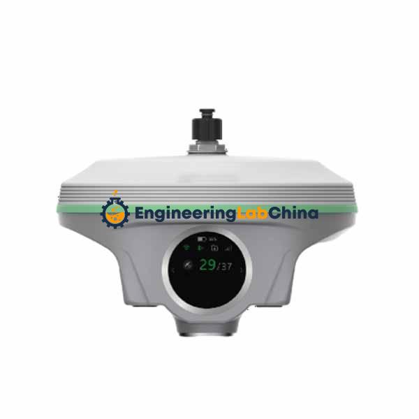
Color LCD Touch Screen
Signal blind zone measurement
3D modeling to recreate reality
Super Radio
Built-in eSIM
Ultra-wide angle lofting
Large battery + super fast charging.
Parameters
Measurement Performance Signal Tracking 1598 Passage
BDS-2:B1I, B2I, B3I
BDS-3:B1I, B3I, B1C, B2a, B2b GPS: L1C/A,L2P,L2C,L5,L1C*
GLONASS: G1,G2,G3*
Galileo?E1,E5b,E5a,E5,E6c* SBAS?L1C/A,L5*
QZSS?L1 ,L2C, L5
IRNSS?L5*
GNSS Characteristics Positioning output frequency: 1Hz?20Hz
Initialization reliability: >99.9% High-reliability carrier tracking technology improves carrier accuracy and provides high-quality raw observation data. Intelligent dynamic sensitivity positioning technology adapts to various environmental changes and is suitable for harsh, long-distance positioning environments.
Initialization time: less than 10 seconds
Global Accuracy Positioning Principle Based on corrections broadcast by Starlink satellites, precise single-point positioning technology is used to achieve high-precision positioning for a single unit.
Positioning Accuracy In a typical operating environment, convergence takes 20 minutes, RMS: 10cm.
Coverage Range Global coverage:
Positioning Accuracy Static GNSS Measurement Horizontal: ±(2.5mm+0.5×10??D); Elevation: ±(5mm+0.5×10??D) (D is the measured baseline length in mm)
Real-time Dynamic Measurement Horizontal: ±(8mm+1×10??D); Elevation: ±(15mm+1×10??D) (D is the measured baseline length in mm)
Inertial Navigation System/Sensor Inertial Navigation Tilt Measurement Built-in IMU inertial measurement sensor, supports inertial navigation tilt measurement function, automatically corrects coordinates according to the tilt direction and angle of the centering rod.
IMU Update Rate 200Hz
Tilt Angle 0°~60°
Tilt Compensation Accuracy 1.8m rod; RMS: 8mm+0.3mm/°tilt (tilt is the tilt angle)
Southern "Smart Cloud" AI Model Intelligent Learning Automatic target object identification, employing precise single-point positioning technology to achieve high-precision positioning of a single unit. Human-computer interaction Voice control, freeing up your hands.
Multi-engine Algorithm Built-in Southern Multi-Engine Algorithm, automatically selects the optimal algorithm based on the operating environment.
BeiDou Short Message Service (Optional) No mobile network required; quickly sends text, images, coordinates, and other information to mobile devices via BeiDou satellite.
Electrical Power Supply 6-18V wide-range DC design with overvoltage protection
Battery Built-in 10000mAh high-performance lithium battery (7.2V), supports PD fast charging; provides up to 30 hours of battery life for mobile station handheld network mode operation.
Scenarios Real-Scene Slab Laying Out Real- Layout Method 2MP + 8MP; Dual-camera joint sampling Visual range of layout points 100m and above
Scene Measurement Pixels 8MP Accuracy Typical operating scenario: measurement distance 2-15m, RMS accuracy: 1-4cm
Communication I/O Ports TYPE-C interface: charging, static data transmission, etc.; 5-pin LEMO port: power supply, RS232 serial data transmission, etc.; SIM card slot (micro SIM)
Radio Station Built-in transceiver radio, operating frequency: 410-470MHz; Supports network routing function: received network signals can be forwarded as radio signals for use by other devices. Operating System/User Interaction Operating System Linux.
Buttons Power Button
LCD Screen 1.39-inch Circular Color Touchscreen, Resolution: 454*454
Indicator Lights Battery Indicator
Web Interaction Built-in Web UI Management Backend, supports Wi-Fi and USB access. The receiver's built-in Web UI management page allows real-time monitoring of host status and flexible host configuration.
Hardware Dimensions 155mm*98.5mm Humidity 100% condensation resistant
Weight 1.2kg Protection level IP68 rating
Material Magnesium alloy Shock resistance Resistant to a 2-meter drop from a pole
Temperature Operating temperature: –45 °C to +75 °C; Storage temperature: –55 °C to +85 °C
Supports radio repeater function: received radio signals can be forwarded again for use by other devices.
Bluetooth BT4.2 (BR/EDR+BLE) Bluetooth standard
4G Full Network Compatibility Based on Linux platform intelligent PPP dialing technology, automatic real-time dialing, continuous online operation, equipped with a 4G full network high-speed communication module, compatible with various CORS system access.
eSIM Card Utilizes eSIM card technology, with an embedded eSIM chip, no card insertion required, providing real-time network resources to ensure continuous online operation of the host network; also supports external card solutions.
NFC Wireless Communication Employs NFC wireless communication technology; the handheld device and main unit can automatically pair via Bluetooth simply by touching each other (the handheld device must also be equipped with an NFC wireless communication module).
WiFi Standard 802.11b/g/n standard.
WiFi Hotspot Features a Wi-Fi hotspot function, allowing any smart device to connect to the receiver and configure its functions.
WiFi Data Link The receiver can connect to Wi-Fi for differential data transmission and reception.
Sensors Temperature Sensor Built-in temperature sensor, using intelligent variable frequency temperature control technology, to monitor and adjust the main unit temperature in real time.
Data Storage Data Storage Built-in 64GB solid-state storage, expandable; automatic cyclic storage (automatically deletes the oldest data when storage space is insufficient); rich sampling intervals, supporting raw observation data acquisition up to 20Hz.
Data Format Static data formats: STH format, format; Differential data formats: RTCM3.0, RTCM3.2 input and output. GPS output data formats: NMEA 0183, PJK plane coordinates, binary code; Network modes supported: VRS, FKP, MAC, NTRIP protocol supported.